ファイル:Cadarache (red dot) CIA World Factbook map.png
ナビゲーションに移動
検索に移動
高解像度版はありません。
Cadarache_(red_dot)_CIA_World_Factbook_map.png (327 × 350 ピクセル、ファイルサイズ: 15キロバイト、MIME タイプ: image/png)
_CIA_World_Factbook_map.png)
概要
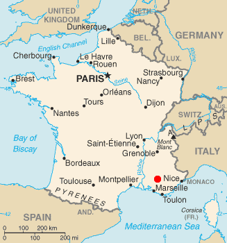
After seeing http://upload.wikimedia.org/wikipedia/en/5/56/1cadarache-arrow.JPG[リンク切れ], my eyes hurt from its highly unprofessional look. I was sure I could do better in 10 seconds, so here is a map showing (roughly) the location of the Cadarache research center. The map is based on the CIA World Factbook article on France updated in November 2005, with a red dot placed as accurately as I could on the location of Cadarache, based on the ugly image mentioned above and external maps.
ライセンス
このファイルは、アメリカ合衆国の連邦政府と雇用関係にある公務員がその職務上作成したアメリカ合衆国政府の著作物であり、アメリカ合衆国の著作権法上パブリックドメインに属します (17 U.S.C. §105)。
注意:このライセンスは、アメリカ合衆国政府の著作物についてのみ効力を有します。アメリカ合衆国の各州、郡、その他の地方自治体が作成した著作物に対しては適用できません。
|
 | |
| このファイルは著作権法の既知の制約(隣接権や関連する権利を含む)から自由であると特定されています。 | ||
ファイルの履歴
過去の版のファイルを表示するには、その版の日時をクリックしてください。
| 日時 | サムネイル | 寸法 | 利用者 | コメント | |
|---|---|---|---|---|---|
| 現在の版 | 2012年1月6日 (金) 20:24 | | 327 × 350 (15キロバイト) | wikimediacommons>Quibik | Removed the thin border. |
ファイルの使用状況
以下のページがこのファイルを使用しています:
_CIA_World_Factbook_map.png)