ファイル:G-F triangulation.jpg
ナビゲーションに移動
検索に移動
高解像度版はありません。
G-F_triangulation.jpg (272 × 400 ピクセル、ファイルサイズ: 21キロバイト、MIME タイプ: image/jpeg)
概要
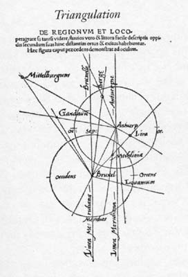
| 解説 | Gemma Frisius's 1533 diagram introducing the idea of triangulation into the science of surveying. Having established a baseline, eg the cities of Brussels and Antwerp, the location of other cities, eg Middelburg, can be found by taking its compass direction at each end of the baseline, and plotting where the two directions cross. Note that this was only a theoretical presentation of the concept -- because of hills etc, it is in fact actually impossible to see Middelburg from either Brussels or Antwerp! Nevertheless, the figure soon became well known all across Europe. |
| 日付 | |
| 原典 | Libellus de locorum describendorum ratione. This scan found at [1] |
| 作者 | Gemma Frisius |
![[1]](http://www.math.yorku.ca/SCS/Gallery/images/G-F_triangulation.jpg)
ライセンス
|
この著作物は、著作権の保護期間が著作者の死後100年以下である国・地域においてパブリックドメインの状態にあります。 | |
| このファイルは著作権法の既知の制約(隣接権や関連する権利を含む)から自由であると特定されています。 | |
ファイルの履歴
過去の版のファイルを表示するには、その版の日時をクリックしてください。
| 日時 | サムネイル | 寸法 | 利用者 | コメント | |
|---|---|---|---|---|---|
| 現在の版 | 2008年4月30日 (水) 17:46 | | 272 × 400 (21キロバイト) | wikimediacommons>Jheald | {{Information |Description=en:Gemma Frisius's 1533 diagram introducing the idea of en:triangulation into the science of surveying. Having established a baseline, eg the cities of Brussels and Antwerp, the location of other cities, eg Middelberg |
ファイルの使用状況
以下のページがこのファイルを使用しています: