ファイル:LA2-Europe-UTM-zones.png
ナビゲーションに移動
検索に移動

このプレビューのサイズ: 553 × 599 ピクセル。 その他の解像度: 221 × 240 ピクセル | 443 × 480 ピクセル | 960 × 1,040 ピクセル。
元のファイル (960 × 1,040 ピクセル、ファイルサイズ: 219キロバイト、MIME タイプ: image/png)
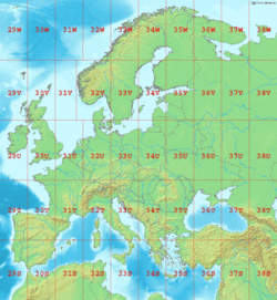
Map of Europe, showing the latitude and longitude zones of the en:Universal Transverse Mercator coordinate system, from 29S to 38W.
Bounding box West -12°, South 32°, East 48°, North 72°. Center at 52°00′N 18°00′E / 52.00°N 18.00°E.
この著作物は、demis.nl/products/web-map-server/examples/を入手元として、著作者により公開されたものであるため、パブリックドメインの状態にあります。この地図は、www.demis.nlからの著作権フリーの画像を基にしているため、コピーや配布、変更が許可されています。ドイツ語版ウィキペディアのメールによる確認と解説もご覧ください。
|
| This work has been released into the public domain by its copyright holder, www.demis.nl. This applies worldwide. 一部の国では、これが法的に可能ではない場合があります。その場合は、次のように宣言します。 www.demis.nlは、あらゆる人に対して、法により必要とされている条件を除き、如何なる条件も課すことなく、あらゆる目的のためにこの著作物を使用する権利を与えます。
|
ファイルの履歴
過去の版のファイルを表示するには、その版の日時をクリックしてください。
| 日時 | サムネイル | 寸法 | 利用者 | コメント | |
|---|---|---|---|---|---|
| 現在の版 | 2006年9月2日 (土) 00:10 | | 960 × 1,040 (219キロバイト) | wikimediacommons>LA2 | Map of Europe, showing the latitude and longitude zones of the en:Universal Transverse Mercator coordinate system, from 29S to 38W. Bounding box West -12°, South 32°, East 49°, North 72°. Center at {{coor d|52.00000|N|18.50000|E|scale:24000000}} |
ファイルの使用状況
以下のページがこのファイルを使用しています: